Thursday
02 July, 2026
RANGPUR, Oct 5, 2025 (BSS) - The Teesta crossed its danger mark (DM) at Dalia point in Nilphamari of greater Rangpur resulting in temporary flooding in
low-lying char areas due to onrushing water amid heavy rains in the upstream during the last 24 hours.
Bangladesh Water Development Board (BWDB) officials said that the intensity of rains has increased in the northeastern states of India and higher parts
of Bangladesh, creating a possibility of temporary flood situation in the Brahmaputra basin's low-lying areas.
"Following a sharp rise in the water level today, the Teesta was flowing above its danger mark by 25cm at 8 pm at Dalia point," Additional Chief
Engineer for Rangpur Zone of BWDB Engineer Dr Mohd Sarfaraz Banda told BSS at 8:20 pm.
Earlier, the river crossed its danger mark by 10 cm at 6 pm at Dalia point. As the water level continued rising, the Teesta was flowing 25cm above the
danger mark at 8 pm.
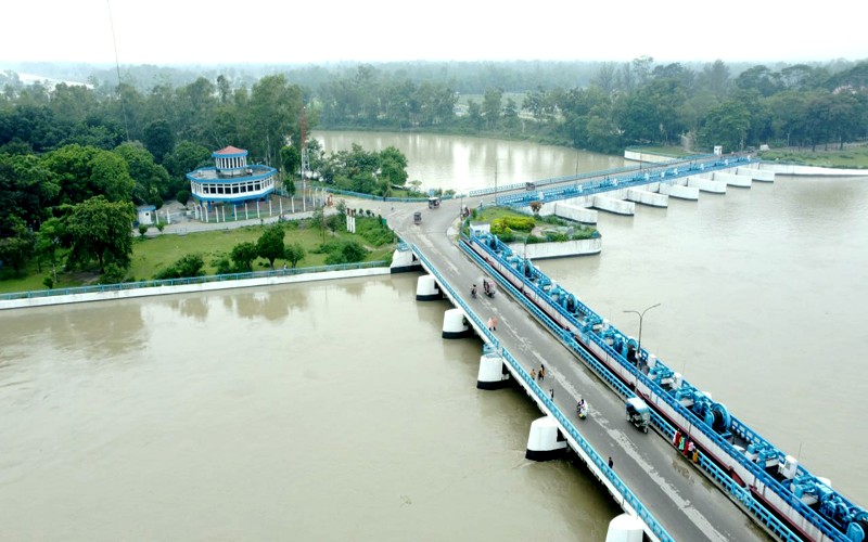
"Currently, all 44 gates of the Teesta Barrage Project are remaining open to control the huge water flow at Dalia point where water levels of the river
were still showing a rising trend," Engineer Dr Mohd Sarfaraz Banda added.
Meanwhile, some very low-lying char areas along the Teesta in Nilphamari and Lalmonirhat went under water amid torrential monsoon rains and onrush of
water from upstream during the past 24 hours ending this evening.
"We are closely monitoring the situation and ready to take immediate steps, if necessary, to save flood control structures on an emergency basis anywhere
in Rangpur division under BWDB's Rangpur Zone," he said.
Talking to BSS from the riverside area tonight, Executive Engineer of the BWDB's Teesta Barrage Division Engineer Amitav Chowdhury said the sharply rising water level of the Teesta is threatening a few vulnerable points in adjoining Lalmonirhat district.
"I, along with BWDB officials and staff are trying our best to save the flood control embankment by dumping sand bags along the Teesta at the zero point in Kaliganj upazila of Lalmonirhat," Engineer Amitav Chowdhury told BSS from the spot at 8:30 pm.
Meanwhile, the Flood Forecasting and Warning Center (FFWC) of BWDB in a bulletin today said the water level of the Brahmaputra-Jamuna rivers system
has decreased in the last 24 hours.
The water level of the rivers may increase in the next two days and the water level may remain stable for the next three days. However, the flow may be
below the danger mark.
Heavy to very heavy rainfall has been observed in Rangpur division and in West Bengal, Sikkim and Arunachal Pradesh in the upstream of India in the
last 24 hours. The recorded rainfalls in the upstream Indian states during the last 24 hours till 9am today were 261mm at Darjeeling, 190mm at Cooch behar, 172mm at Jalpaiguri, 89mm at Pasighat and 88mm at Gangtok and 47mm Cherrapunji points.
"During the same period, 200mm rainfall was recorded at Panchagarh, 132mm at Dalia, 128mm at Dinajpur, 36.5mm mm at Kurigram points," the bulletin said.