Thursday
23 July, 2026
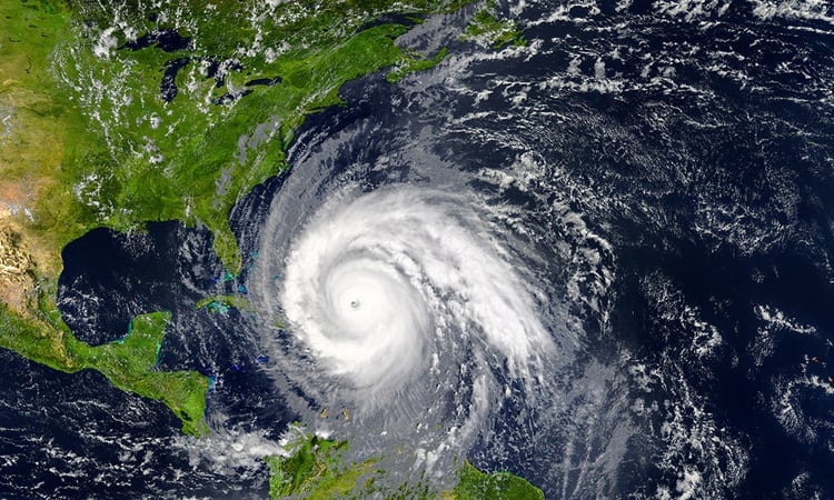
WASHINGTON, Aug 18, 2025 (BSS/AFP) - Hurricane Erin was downgraded to a Category 3 storm Sunday, but forecasters warn it is expected to intensify and grow in size in coming days, as it lashes Caribbean islands with heavy rains that could cause flash floods and landslides.
The first hurricane of what is expected to be a particularly intense Atlantic season, Erin briefly strengthened into a "catastrophic" Category 5 storm before its wind speeds weakened.
Forecasters do not currently expect it to make landfall along its expected course, but tropical storm warnings are in effect for the southeast Bahamas and Turks and Caicos Islands.
Hurricane Erin was located about 275 miles (445 kilometers) north of San Juan, Puerto Rico, at 5:00 pm Atlantic Standard Time (2100 GMT), with maximum sustained winds of 125 miles (205 kilometers) per hour, according to the Miami-based National Hurricane Center (NHC).
"The core of Erin is expected to pass to the east and northeast of the Turks and Caicos Islands and the southeastern Bahamas tonight and Monday," the NHC said in their latest report.
The North Carolina Outer Banks, Bermuda and the central Bahamas were advised to monitor Erin's progress.
Hurricane Erin had reached the highest level on the Saffir-Simpson scale just over 24 hours after becoming a Category 1 storm, a rapid intensification that scientists say has become more common due to global warming.
It could drench isolated areas with as much as eight inches (20 centimeters) of rain, the NHC said.
"Some increase in size and strength is forecast during the next 48 hours. Erin is likely to remain a dangerous major hurricane through the middle of this week," the agency said.
It also warned of "locally considerable flash and urban flooding, along with landslides or mudslides."
- Climate hazard -
In Luquillo, a coastal town of Puerto Rico, surfers rode the swells while beachgoers milled about the shore on an overcast Saturday before the storm approached, AFP images show.
Areas of the US territory -- home to more than three million people -- saw flooded roads and homes.
Swells generated by Erin will spread to the Bahamas, Bermuda and the US East Coast early next week, creating "life-threatening surf and rip currents," the NHC said.
While meteorologists have expressed confidence that Erin will remain well off the United States coast, they said the storm could still cause dangerous waves and erosion in places such as North Carolina.
The Atlantic hurricane season, which runs from June until late November, is expected to be more intense than normal, US meteorologists predict.
Several powerful storms wreaked havoc in the region last year, including Hurricane Helene, which killed more than 200 people in the southeastern United States.
The National Oceanic and Atmospheric Administration -- which operates the NHC -- has been subject to budget cuts and layoffs as part of US President Donald Trump's plans to greatly reduce the size of the federal bureaucracy, leading to fears of lapses in storm forecasting.
Human-driven climate change -- namely, rising sea temperatures caused by the burning of fossil fuels -- has increased both the possibility of the development of more intense storms and their more rapid intensification, scientists say.