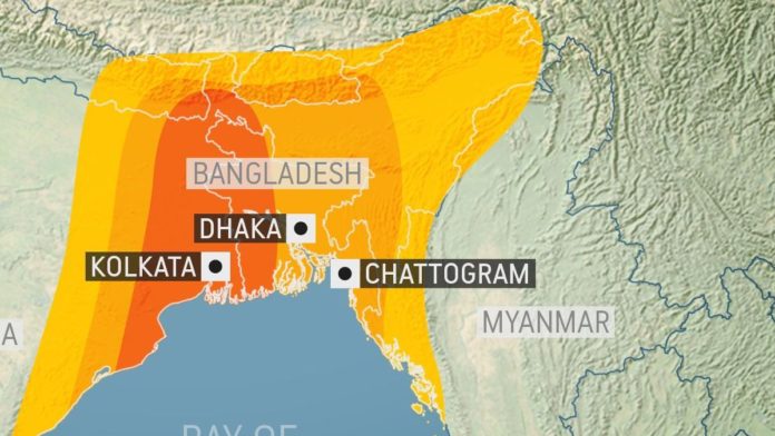
DHAKA, May 19, 2020 (BSS) – Leading global storm tracker AccuWeather today described Amphan as the first super cyclone in Bay of Bengal since 1999, fearing the “ferocious” storm to unleash extreme impacts across Bangladeshi and northeastern Indian coastlines.
“Amphan is the first super cyclonic storm in the Bay of Bengal since the 1999 Odisha Cyclone,” AccuWeather’s Lead International Forecaster Jason Nicholls said as the storm aims to make a landfall on coastlines of both the countries by late Wednesday.
The US-based weather forecasting agency said the cyclone was drifting north-northeastward over the open Bay of Bengal early today while “favorable environmental conditions have allowed for (its) significant strengthening”.
Quoting US Joint Typhoon Warning Center this morning the CNN, meanwhile, reported “Amphan became the strongest storm ever recorded in the Bay of Bengal on Monday night, after intensifying with sustained wind speeds of up to 270 kilometers per hour (165 miles per hours).”
Bangladeshi and Indian meteorologists predicted it to move north-northwest and cross the coastlines of the two countries between Bangladesh’s Hatya of Bhola and India’s Digha, close to the Sundarbans mangrove forest as Bangladeshi and Indian met offices updated their reports this morning.
Bangladesh’s meteorological department said the super cyclone was centred at 9 am today about 845 km southwest of Chattogram Port, 795 km southwest of Cox’s Bazar Port, 730 KM south-southwest of Mongla Port and 725 km south-southwest of Payra Port.
The Indian met office said in the past six hours until this morning the cyclone moved at a speed of 14 kilometres per hour (kp/h)
AccuWeather said latest indications suggest that the Amphan would make the landfall as either a super cyclone storm or an extremely severe cyclonic storm.
“Amphan is expected to bring extreme threats to lives and property across West Bengal and Bangladesh during landfall . . . This includes widespread destructive winds, flooding rainfall and major coastal storm surge flooding,” the weather agency said.
It particularly warned that due to the widespread low elevation in southern Bangladesh, “the region is very susceptible to coastal flooding” under Amphan’s impact.
According to AccuWeather Amphan became a “super cyclonic storm” by Monday evening with sustained wind speeds of 220 kilometre per hour (kp/h), which is rated as a Category 5 hurricane in the Atlantic and East Pacific basins.
The 1999 Odisha Cyclone had produced winds up to 260 kp/h.
The storm meandered over the Bay of Bengal for over a week and developed into a tropical depression on Saturday when World Meteorological Organization (WMO) named it Amphan.in line with a proposal of Thailand, one of the eight countries to suggest cyclone names in the region.
“Amphan is expected to maintain this intensity (220kp/h) on Tuesday as it begins to turn to the north-northeast, tracking toward the head of the Bay of Bengal,” the AccuWeather forecast read.
Echoing Bangladeshi and Indian met offices, the US agency said the cyclone was likely to make landfall on Wednesday night near the border of India’s West Bengal and Bangladesh.
“This path would lead to a direct hit in Kolkata,” it said.
Accuweather said though it expected the storm to be weakened a little just before its landfall, “the cyclone will still be a dangerous storm”.
“Due to the widespread low elevation across southern Bangladesh and southern West Bengal, coastal flooding will be a major concern as winds push water from the Bay of Bengal onshore,” AccuWeather’s Senior Meteorologist Adam Douty commented.
Meteorologists in Bangladesh feared the Amphsan wraths to be very high as its high strength coincided with the “new moon phase” to washout and inundate vast areas of particularly southwestern and central coastlines stretching up to Chottogram.
The CNN television quoting experts reported that even if the storm weakened ahead of its landfall, it could cause significant damage there is also the potential for major storm surges, “perhaps even as high as 30 feet (9 meters)”.
The Washington Post reported Amphan took aim at northeastern India, Bangladesh, “with life-threatening storm surge” while it was the super cyclonic storm is the most intense to form in the northern hemisphere this year, strongest in the record of the Bay of Bengal.
AccuWeather recalled that storms that previously followed a similar path led to thousands of deaths in the past, including the 1991 Bangladesh Cyclone, which, however hit the country’s southeastern coast.
The 1991 cyclone had killed over 138,866 people and the fatality account earned it the infamy of being fifth deadliest tropical cyclone in the world history.
AccuWeather expected the Amphan to quickly lose wind speed while moving inland on Thursday, but warned that the threat of flooding rainfall would continue through the end of the week.
“This cyclone will carry plenty of moisture with it, and rainfall totals of 100-200 mm (4-8 inches) are likely from eastern Odisha to West Bengal, Bihar and Bangladesh from Tuesday into Thursday,” the agency reported.
The weather forecaster said after its landfall the storm would hit the high mountain range of the Himalayas when it would intensity quickly but result in flooding rainfall to spread to the slopes of the eastern Himalayan Mountains into the second half of the week.
“Significant flooding is expected across northeastern India, Bhutan and northern Bangladesh, and mudslides are likely in the eastern Himalayans and the Garo-Khasi mountains,” it warned.


